Short Description
Goals:
Provide information of the forest resource condition to the Ministry of Industry and Natural Resources, Perm Krai Government, local municipal authorities, potential investors and forest users.
Tasks:
- Gather forest mensuration (including annual felling data) and cartographic materials by forest compartment and transport component of Perm Krai forest fund and information on the allocation thereof to the lessees.
- Change the forest fund electronic database structure to comply with the Client’s requirements;
- Update the information in the electronic database of Perm Krai forest fund.
- Change the structure of digital map electronic thematic layers to comply with the Client’s requirements.
- Update the digital map electronic thematic layers to comply with the Perm Krai forest fund electronic database.
- Upgrade the geoinformation system “Wood Raw Material Base of Perm Krai”. Program interface, algorithms of data input, editing and storing in the database and thematic layer attribute tables, as well as report forms and information output thereon to be in compliance with the Client’s requirements.
- Create program modules to ensure data exchange among the “Wood Raw Material Base” software and GIS ArcView and ArcMap.
- Create a “Data exchange” program module to update the data in the forest fund electronic database.
- Create a program module to ensure back-up copying of the forest fund electronic database.
- Upgrade the “Transport Component” and “Dynamics” routines.
- Develop a module for automatic building of thematic maps based on the user’s criteria.
- Develop a module for automatic formation of tender documentation and holding tenders.
- Make a software version to be used in particular forestries.
- Make a software network version.
- Upgrade other software modules.
Results:
- Data of the existing Perm Krai forest resources gathered and updated in the electronic database; visualization thereof.
- The electronic data bank (including the cartographic materials) of forest resources can be used for developing investment proposals in the timber industry complex within short time.
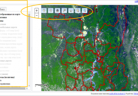
- Integrated processing of spatial (cartographic) and attributive data, interaction with all electronic layers of forest resources, including the transport component, advanced facilities for working with cartographic information directly in the software for any level user.
- Detailed and extended output on report forms of the forest resource data available in the data bank.
- Review and print-out of any graphical object relating to the forest resources.
- Continuous monitoring and detail analysis of the forest reserve condition, including assessment of merchantable and assortment structure of forest plantations.
- Monitoring of the forest resource condition and use.


